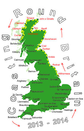
Log No 101. Sun 4th Aug 2013 - W of Arevegaig to Ardnamurchan Pt, 17 miles (1582 miles walked)

| Mick on footpath to Ockle |
We hadn't been going long when the rain came in earnest, just like yesterday and still with a strong wind.
It was a good path to walk on, more or less following the contours along the crags, at one point the sun was out behind us and we had a good, short-lived, rainbow ahead of us.

| Looking to Ockle |
With all the rain over the last couple of days there was plenty of water about and a lot of it running down the tracks.
The rain had stopped and the sun was coming out as we reached Ockle and from there we walked on the minor road through Kilmory and Branault, turning right at the junction and following it to the end at Fascadale on the coast.

| Dave crossing Allt Fascadale |
It was only mid-calf deep but quite wide.
The path was inland a bit and we had to leave it after 2 miles as it turned south to meet up with a road.

| Mick crossing a stream |
We stayed inland to make for Sanna but were thwarted from getting to the road by the river Allt Sanna. It didn't look much on the map but it was too wide and too deep to cross.
We were forced to follow it through more boggy ground almost as far as the coast before we came to a footbridge.

| Mick looking back to Sanna Bay |

| Dave looking to Portuairk |
Fortunately the stones weren't slippery as they are normally above the water, otherwise I doubt we could have got across until low tide.
From Portuairk it was another footpath to Macneil Bay then through a private caravan site. I couldn't understand why the footpath signs directed us off the track through the site on a detour to the road, we stuck the track. When we came to the 6' high gate onto the road we found out why the path detoured, the gate was kept locked, but after climbing deer fences this was no problem.

| Dave at Ardnamurchan Lighthouse |
We took our photos of the lighthouse and were about to head back down the road to find a pitch for the tents when, after saying "Hi" to a couple of chaps in a campervan, were asked if we fancied a beer.
Mike and Andy were up from Bristol touring for 3 weeks, we spent a pleasant few mintues chatting to them while we drank a "cold one".
17 miles of good walking and interesting crossings. Still no phone signal.