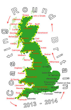
Log No 279. Wed 9th Apr 2014 - Seaton to Kingsand, 14 miles (4243 miles walked)

| Looking back to Downderry |
Leaving the village we had what seemed a very long climb straight up to the highest point on the cliffs for today, it was just a pity that it wasn't all downhill from that point.

| The coastline to Portwrinkle |
We got to Portwrinkle at 09.30 and stopped for an early sandwich break, I hoped to upload yesterdays log but still had no phone signal.
Getting to the end of the village we saw a cafe with Free WiFi so we took a second break here for a drink and managed to update the website.
We ended up spending an hour in the village.

| Mick looking back to Portwrinkle |
The next place we came to was Freathy and the path wss mainly along the road since the land sloped steeply down to the sea.

| The coastline from Freathy |

| Dave looking to Rame Head |
The small headland is a popular walking spot with two car parks a mile apart at each end of the west & east points, the westerly point had an old chapel.

| Cawsand |
The two co-joined villages, Cawsand & Kingsand are tucked into the corner of Cawsand Bay and each had a small sheltered beach.
A short distance after leaving Kingsand we turned off the path to head uphill for half a mile to the campsite at Maker Heights, getting there at 15.30.
Maker Camping is basic with simple amenities and caters for all.
After much thought we are having two nights here, the next two days were looking a bit complicated for finding campsites so we will have a longer pack-free day tomorrow to get to Plymouth.
14 sunny miles.