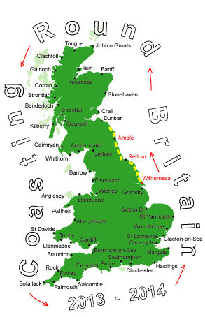
Log No 15. Sat 13th Apr 2013 - Beal to Scotttish Border via Holy Is, 26 miles (263 miles walked)

| The Causeway to Holy Island |
The tide had gone out far enough for the causeway to be clear and it seemed like a lot of road walking before I got to the main part of the island.

| Emmanuel Head |
I continued round past Lindisfarne Castle and into the village where I bought a banana & a sausage roll, I was a bit short on provisions.

| Holy Island harbour & village |
There are a line of poles marking the original route to the island and James had said you could walk along it, it is shorter than the road.
I briefly considered this option but after yesterday decided to stick to the road.
Plodding back on the road I could see some people apparently walking along the poles, both routes had an elevated shelter on stilts about halfway across for anyone caught out by the tide.

| A Horny Toad? |
Back on the Coast Path again I went by Beachcomber Ho, there was a campsite symbol here on the map but this was long closed.
It was now along a road for a bit, a small section of footpath between the golf course & railway. My achilles was aching so I had a 25 min break lying on the grass before getting on to the tarmac'd cycleway & road for an hour, I did see some wildlife.

| Berwick Upon Tweed |
The only campsite shown on the map was right at the south end, I went to have a look but it was just a chalet park, oh well, the next one is 5 miles away.
I stopped at Asda at 16.10 for an early meal, very cheap, then stocked up before continuing.
I followed the rampart for a bit then onto the cliff top by the golf courses then the railway lines, getting to the campsite at Marshall Meadows for 18.30, guess what? it was only a chalet park!
Well Scotland was only a half mile away so I crossed the border for my first wild camp.