HomeEnd

Coasting Round Britain

30th March 2013 to 12th July 2014
Whithorn to Auchencairn (29)
2454 out of 5630 miles completed

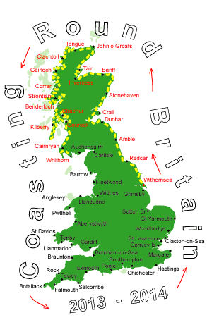
Log No 158. Sun 13th Oct 2013 - Isle of Whithorn to Garlieston, 8 miles (2454 miles walked)

The Tower at Isle of Whithorn
I'm planning on meeting up with Mick on Saturday at Kirkcudbright and as this is only 70 miles or so away I need to have some shorter walks, otherwise I'll be kicking my heels for a couple of days and they're painful enough as they are.

So today it was only 8 miles to Garlieston.

It was another dry day, sunny but quite a cold northeast wind.

St Ninian's Chapel
Why is Isle of Whithorn called "Isle of"? it doesn't look as though it was once an island.

Anyway I went to look at the big square Tower and St Ninian's Chapel. I've no idea what the Tower is all about, it doesn't have any entrance that I can see.

The coastline from Isle of Whithorn
Having played the tourist I set off walking along the road.

I had only been going half an hour when a I saw a footpath signpost saying "Garlieston 6 miles". There was no footpath shown on the map so this was a bonus.

The Castle
The footpath was along the edge of the fields with kissing gates. Most of the fields had cattle in but they showed no interest in me.

The Castle
The map shows this stretch of coastline as having a lot of forts but the only evidence I have noticed is what could be a ditch & embankment at one of the locations.

The Castle cannot be missed, being sited on the highest bit of coastline here.

Footpath from the Castle
The well established footpath from the Castle to Garlieston was very pleasant to walk and almost all through woodland.

An enjoyable 3 hours.